1. In 1888, the Supreme Court restated the legal procedure of the original survey. What was the case then under consideration?
Choice 1 a. Ordinance of May 20, 1785
Choice 2 b. Cragin vs. Powell
Choice 3 c. The Act of July 4, 1836
Choice 4 d. The Act of March 3, 1909
2. The method of restoration by proportionate measurement should be the first consideration for restoring lost comers.
True
False
3. Rules for restoration of lost corners were first published by the Department of Interior in 1883.
True
False
4. What body passed legislation authorizing activity by BLM surveyors on both public and private lands?
Choice 1 a. Department of the Interior
Choice 2 b. The Supreme Court
Choice 3 c. The Congress of the United States
Choice 4 d. A combine formed by the Public Land States
5. Is a "mile" always 80 chains?
Choice 1 a. Yes
Choice 2 b. No
6. Where in a township are "half miles" most often short or long?
Choice 1 a. Along the North and West Boundaries1
Choice 2 b. Along meander lines
Choice 3 c. Against Grants
7. To restore an original meander line, what kind of adjustment would be used?
Choice 1 a. Compass rule
Choice 2 b. Bowditch method
Choice 3 c. Nonriparian angle point adjustment
Choice 4 d. All of the above
8. A lost corner can be restored only by reference to:
Choice 1 a. Original accessories
Choice 2 b. Testimony
Choice 3 c. Acceptable record evidence
Choice 4 d. One or more interdependent corners
Choice 5 e. All of the above
9. Should an obliterated corner be restored using proportionate means?
Choice 1 a. Yes
Choice 2 b. No
10. A term applied to a new measurement made on a line to determine one or more positions on that line.
Choice 1 a. Retracement
Choice 2 b. Resurvey
Choice 3 c. Single proportion measurement
11. A term applied to a new measurement made between four known corners, two each on intersecting meridional and latitudinal lines, for the purpose of relating the intersection to both.
Choice 1 a. Two point control
Choice 2 b. Double proportionate measurement
Choice 3 c. Grant boundary adjustment
12. Where in a township would special consideration be applied for geodesy or curvature of the earth?
Choice 1 a. On the exterior Boundaries of the township
Choice 2 b. Along meander lines
Choice 3 c. Along the north and south boundaries of the township
13. Complete the problem below using information in the diagram.

P1 = 37.375

Choice 1 a. Yes
Choice 2 b. No

P2 =

Choice 3 a. 39.292
Choice 4 b. 40.15
Choice 5 c. 38.091

P3 = 38.333

Choice 6 a. Yes
Choice 7 b. No


14. Using the data in the above diagram, compute the moves from the temp.
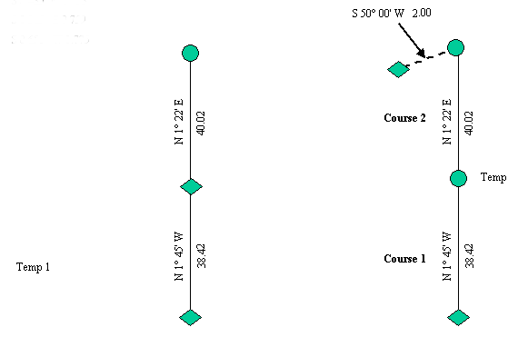
Moves =

Choice 1 a. S 0.435 W 0.753
Choice 2 b. S 0.365 E 0.759
Choice 3 c. S 0.651 W 0.775

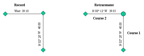
15. In this problem, two comers have been lost. Using the record and retracement data given, compute the moves for both from the temps.

P1 =

Choice 1 a. S 0.017 E 0.298
Choice 2 b. N 0.015 W 0.305
Choice 3 c. S 0.020 E 0.197


P2 =

Choice 4 a. S 0.087 E 0.251
Choice 5 b. S 0.025 W 0.405
Choice 6 c. S 0.034 E 0.596

16. In the situation shown here, how would you determine the departures for C1 and C2 and the latitude for C3?
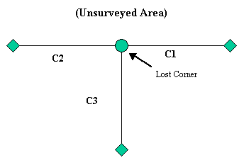
C1 and C2

Choice 1 a. Record Distance
Choice 2 b. Single proportion
Choice 3 c. Two point control

C3

Choice 4 a. Record Distance
Choice 5 b. Single proportion
Choice 6 c. Two point control


17. In the following diagram, what is the name of the method used to restore the lost corner?
Choice 1 a. Record Distance
Choice 2 b. Double proportion
Choice 3 c. Two point control
18. In the above diagram, the lost comer should be restored by:
Choice 1 a. record bearings to intersection, the angle between corners must remain record.
Choice 2 b. record latitude on the meridional line and record departure on the latitudinal line and then cardinal offsets to fix the corner point.
Choice 3 c. record for the north/south line as it is ran first in the rectangular system, and therefore, senior.
Choice 4 d. the irregular boundary adjustment.
19. If a lost corner is related in the record to only one control corner, what things could determine a restoration of that comer?
Choice 1 a. Record bearing and distance
Choice 2 b. Testimony
Choice 3 c. Index correction
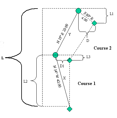
20. Complete the formulas for determining the proportionate latitude and departure of the lost corner in this irregular exterior example: L1 / L =
Choice 1 a. L3 / L
Choice 2 b. L2 / L3
Choice 3 c. L3 / L2
21. Using the data in the above diagram, compute the proportionate courses and moves from temp. The record was run to the temps.

Course 1 =

Choice 1 a. N 10° 59' W 41.093 S 0.412 E 2.330
Choice 2 b. N 10° 40' W 41.080 S 0.422 E 2.780
Choice 3 c. S 9° 35' W 39.156 S 0.257 W 1.895

Course 2 =

Choice 4 a. N 18° 19' E 30.173 S 0.657 E 3.098
Choice 5 b. N 15° 25' W 31.055 S 0.645 E 3.578
Choice 6 c. N 18° 12' E 29.189 S 0. 695 E 3.939


22. In a final problem, compute the corrected courses for this grant boundary (see diagram below). Record lines were run, temps. placed, and the closing error measured.

Course to P1

Choice 1 a. S 62° 58' W 34.264 N 2.358 W 2.457
Choice 2 b. N 57° 45' W 35.554 N 1.985 E 2.735
Choice 3 c. S 63° 00' W 35.173 N 2.127 W 2.378

Course to P2

Choice 4 a. S78° 48' W 14.264 N 3.224 W 2.645
Choice 5 b. N 78° 45' W 15.554 N 3.985 W 2.760
Choice 6 c. N 78° 40' W 15.120 N 3.478 W 2.612


Course to P3

Choice 7 a. N 55° 54' W 33.185 N 6.412 W 1.940
Choice 8 b. N 54° 45' W 33.594 N 6.421 E 1.890
Choice 9 c. S 55°56' W 33.945 N 6.159 W 1.268

Course to P4

Choice 10 a. S 87° 12' W 58.707 N 11.276 W 4.104
Choice 11 b. N 87° 45' W 57.254 N 12.035 E 4.057
Choice 12 c. S 88° 00' W 58.256 N 11.249 W 4.058