Skip Navigation
Restoration of Lost Corners by Proportionate Measurement
 
  Page 27 of 27   Unit 1 Unit 2 Unit 3 Unit 4 Unit 5 Open the course map. Open the glossary.
Open the calculator. Open the resources page. Go to Previous Page Previous   Next Go to Next Page
  Section 2 - Review Exercise

   
1. Many grants and reservations are irregular in shape because:
Choice 1 a. they were established prior to public land subdivisional surveys and may also follow topographic features.
Choice 2 b. There are numerous lost corners.
Choice 3 c. some were so large, the convergence of meridians caused the north boundary to be shorter than the south boundary.
2. If the total record course is found to be 3° to the left of the true, how much change could be applied to individual courses, and in what direction?
Choice 1 a. 3°/n and to the right
Choice 2 b. 3° to the left
Choice 3 c. n/3° and to the right
Choice 3 d. 3° to the right
3. Grant boundaries should maintain "shape conformity." This means that all interior angles should:


Choice 1 a. Have an index correction applied.
Choice 2 b. Remain the same.
Choice 3 c. Be adjusted to agree with your retracement.
4. If a retracement finds that the actual distance between two identified points is 2 percent shorter than the record distance, what should be done to all record distances for courses between those identified points?
Choice 1 a. They should be lengthened by 2 percent.
Choice 2 b. They should be left unchanged.
Choice 3 c. They should be shortened by 2 percent.
5. The previous question dealt with a change in scale. Briefly, what does this mean?

Choice 1 a. All lines are increased or decreased in length, proportionately.
Choice 2 b. A mapping angle is used to adjust record data.
Choice 3 c. The lengths of lines are adjusted to fit the record.

6. If the position of a natural object of topography is mentioned in the field notes, but its position differs from your proportionate resurvey, which position would be given precedence?
Choice 1 a. Your proportionate position.
Choice 2 b. The natural feature
7. When a series of record courses is run, the line between your starting point and the end point is called:
Choice 1 a. the closing error
Choice 2 b. the irregular boundary error
Choice 3 c. the record connecting line.
Choice 4 d. the connecting bearing
8. What would you call a line between your starting point and the identified original?

Choice 1 a. Tie
Choice 2 b. The control connecting line.
Choice 3 c. The control record line.
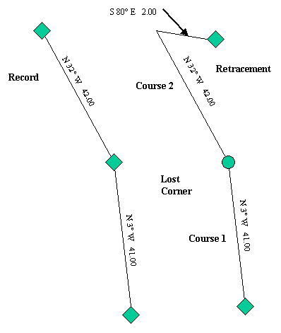
9. Below are shown the record and retracement of a portion of a grant boundary. Using the concepts stated above, compute the true bearings and distances of the proportionate courses.

Course 1
Choice 1 a. N 1° 43' W 40.53
Choice 2 b. N 1° 05' E 40.25
Choice 3 c. N 1° 08' E 40.65

Course 2
Choice 4 a. N 30° 35' W 41.47
Choice 4 b. N 32° 05' W 41.95
Choice 4 c. N 30° 43' W 41.52

Needed Downloads
Go to Previous Page Previous   Next Go to Next Page