Skip Navigation
Restoration of Lost Corners by Proportionate Measurement
 
  Page 10 of 35   Unit 1 Unit 2 Unit 3 Unit 4 Unit 5 Open the course map. Open the glossary.
Open the calculator. Open the resources page. Go to Previous Page Previous   Next Go to Next Page
  Section 1 - Review Exercise
 
1. Which of the following statements best describes the purpose of any resurvey procedure?
Choice 1 a. To correct the flaws or errors of the original survey.
Choice 2 b. To accurately determine where the original comer was placed in the beginning.
2. The method of restoration by proportionate measurement should be applied only after all other means have been exhausted.

True
False
3. The rules of restoration of lost comers have remained essentially unchanged since:

Choice 1 a. Ordinance of May 20, 1785.
Choice 2 b. The Manual of 1855.
Choice 3 c. The 1883 publication by the Department of the Interior.
Choice 4 d. The Manual of 1930.
4. Legally, what is a resurvey?
Choice 1 a. The establishment of independent initial points.
Choice 2 b. Establishment of proper comers of the rectangular survey system.
Choice 3 c. A word synonymous with rectification of defective exterior boundaries.
Choice 4 d. A retracement with a view to determine and establish lines and boundaries of an original survey.
5. Private lands may be resurveyed if it is necessary to properly identify:
Choice 1 a. Lands under federal control.
Choice 2 b. Bona fide rights.
Choice 3 c. When the original survey was not honestly executed.
6. In all resurveys, it is required that no resurvey shall impair or diminish:
Choice 1 a. The qualifications of a witness.
Choice 2 b. Hearsay evidence.
Choice 3 c. Bona fide rights.
7. By definition, a mile equals 80 chains. Although a retracement may find it longer or shorter, it may still be referred to as a mile.

True
False
 
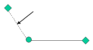
8. What name is NOT synonymous with the line indicated in the diagram to the right?

Choice 1 a. Closing Error
Choice 2 b. Closing Distance
Choice 3 c. Error of Closure
Choice 4 d. Tie
Choice 4 e. Residual Error
9. The error of closure is defined in general terms as the ratio of the length of the line representing the equivalent of the errors in latitude and departure to the length of the perimeter of the figure constituting the survey.

True
False
10. A point on the earth's surface determined by the surveying process is:

Choice 1 a. monument
Choice 2 b. corner
Choice 3 c. a record
Choice 4 d. physical object
11. An existent corner means that the monument is still there.

True
False
12. An interdependent corner used to restore a lost corner is called a:
Choice 1 a. control corner
Choice 2 b. spurious corner
Choice 3 c. harmonious corner
Choice 4 d. correction corner
Needed Downloads
Go to Previous Page Previous   Next Go to Next Page